2009. Charles St view of old Kaiapoi Railway Station Building, Kaiapoi Wharf, Kaiapoi. The Kaiapoi Railway Station bldg was badly damaged by the 4 Sept 2010 quake

2009. Kaiapoi Railway Station Plaque, Kaiapoi Wharf, Kaiapoi

2009. MV Tuhoe moored by Kaiapoi Wharf, Kaiapoi. The Kaiapoi Railway Station bldg left & wharf were badly damaged by the 4 Sept 2010 quake
I drove to Kaiapoi, about 20kms from Burnside Christchurch, and parked my car at Kaiapoi Wharf by Charles St on the north bank of Kaiapoi River. I wanted to walk downstream on the stopbank Pegasus Bay Walkway, beyond Kaiapoi River / Waimakariri River confluence towards Waimakariri River mouth by Pines Beach on the Pacific.

2009. Kaiapoi River Boats moored by Kaiapoi Wharf, Kaiapoi. The wharf was damaged by the 4 Sept 2010 quake

2009. Kaiapoi Wharf, Waimakariri Harbour Sign, Kaiapoi Wharf, Kaiapoi

2009. Pleasure Boat, Kaiapoi Wharf, Kaiapoi River, Kaiapoi

2009. Kaiapoi Wharf view of Whitebaiter & Moored Boats in Kaiapoi River, Kaiapoi

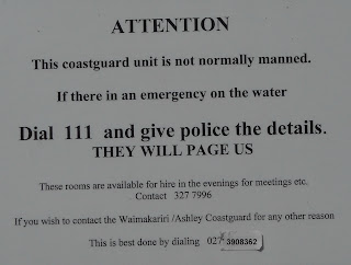
2009. Kaiapoi Coastguard Building, Kaiapoi Wharf, Kaiapoi. The Coastguard bldg & wharf were damaged by the 4 Sept 2010 quake

2009. Kaiapoi Coastguard Door Sign, Kaiapoi Wharf, Kaiapoi
I lingered at Kaiapoi Wharf while looking at old Kaiapoi Railway Station; Kaiapoi Wharf and Waimakariri Harbour sign; MV Tuhoe; other boats; whitebaiter; Coastguard building; boatramp.
A concrete path along the stopbank top led me beside Kaiapoi River willows and birches, and houses on the north bank, and new houses by Raven Quay. Opposite Raven Quay I passed a waterlogged willow island, as it was high tide.

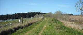
2009. Stopbank, Pegasus Bay Walkway, Kaiapoi River, Kaiapoi. The stopbank was damaged by the 4 Sept 2010 quake

2009. Pegasus Bay Walkway view of Houses by Raven Quay, Kaiapoi River, Kaiapoi

2009. Stopbank Concrete Path, Pegasus Bay Walkway, Kaiapoi River, Kaiapoi. The stopbank path was damaged by the 4 Sept 2010 quake
Further on, I found a concrete and mosaic plinth by a bench. On top of the plinth an iron bird wheeled in the northwest wind. At the bottom on four sides words said:
* Walk the path *
* the river flows *
* the days pass *
* all is one *

2009. Stopbank, Pegasus Bay Walkway view of Bird Statue by Kaiapoi River, Kaiapoi. The stopbank walkway & statue were damaged by the 4 Sept 2010 quake
A raven-haired woman passed, wearing joggers, black pants, red vest and iPod. I wore jandals, shorts, T shirt and green wind-cheater, as the nor-wester chilled the stopbank. By Askeaton Park, at a bend in the river, a boatie chugged upstream between willows.

2009. Kaiapoi River Boat, Askeaton Park, Kaiapoi
I passed a public loo on the stopbank, then sidled down to another boatramp by Kaiapoi River, near the BMX Track. By the boatramp, I looked at a Waimakariri River Harbour and Brooklands Lagoon sign, with many boatie rules and a warning "...Swimming in Waimakariri River is dangerous and not advised..." I passed a "Dumping Prohibited" sign by the boatramp carpark.

2009. Kaiapoi BMX Track near Kaiapoi River

2009. Kaiapoi River Boatramp near Kaiapoi BMX Track

2009. Kaipoi River Boatramp Info Board, Boatramp near Kaiapoi BMX Track

2009. Dumping Prohibited Sign, near Kaiapoi River Boatramp & BMX Track

2009. Stopbank, Pegasus Bay Walkway Stile near Kaiapoi BMX Track & Boatramp
Back on the stopbank, Pegasus Bay Walkway, at the end of Kaiapoi I crossed a stile, and found a sign stating:
Pegasus Bay
Walkway
1 hour 30 minutes to Pines Beach
5 hours to Waikuku

2009. Stopbank Bridge, Pegasus Bay Walkway view of Whitebaiters by a Creek near Kaiapoi River
On my right I passed a Kaiapoi River swamp, on my left a series of paddocks, the first with black cattle. By a creek I coolpixed two whitebaiters.

2009. Stopbank, Pegasus Bay Walkway eastwards view of Stile by Paddocks near Kaiapoi River
I crossed another stopbank stile, and near Ferry Road cul de sac a young man with iPod and friendly, leashed pitbull passed. They left the stopbank by parked cars. I sidled down to Waimakariri River to look at Kaiapoi River / Waimakariri River confluence upstream on my right. I watched a whitebaiter with his big net wandering through willows.

2009. Waimakariri River upstream view of Waimakariri River / Kaiapoi River Confluence

2009. White Faced Heron in Raupo Swamp, between Kaiapoi Sewage Farm & Waimakariri River

2009. Whitebaiters, Waimakariri River. Kaiapoi River Confluence right behind Whitebaiters

2009. Waimakariri River Mouth seen from Ferry Road river track, Kaiapoi
I walked downstream along a track beside Waimakariri River. I watched a white faced heron perched on a branch in a raupo swamp. Three bearded whitebaiters passed, laden with gear. One sported a ponytail. Lots of whitebait fishermen during the recession, on the dole. Grim faced, they must've thought I was a fishery officer coolpixing their catch.
At a 5 knots sign beside Waimakariri River, I watched another whitebaiter camped on the opposite bank, about 200m away. Waimakariri River flowed fast, deep, green and dangerous past a distant Yacht Club towards the Pacific.

2009. Stopbank, Pegasus Bay Walkway eastwards view of Raupo Swamp near Ferry Rd, Kaiapoi

2009. Kaiapoi Sewage Treatment Plant Info Board by Pegasus Bay Walkway

2009. Pegasus Bay Walkway eastwards view of Kaiapoi Sewage Farm left & Raupo Swamp right

2009. Jockey Baker Creek below Kaiapoi Sewage Farm. Waimakariri River & Port Hills backdrop

2009. Duck in wetland below Kaiapoi Sewage Farm, Jockey Baker Creek. Waimakariri River & Port Hills / Banks Peninsula backdrop
When the track ended by the raupo swamp beside Waimakariri River, I returned to the stopbank, Pegasus Bay Walkway. With raupo swamp on my right, I passed Kaiapoi Sewage Farm on my left, the wind wafting a nasty smell.
In oxidation ponds, gulls, ducks and two black swans floated in cruddy waters. "Clean" water flowed into Jockey Baker Creek below Kaiapoi Sewage Farm. I coolpixed a duck in wetland below Kaiapoi Sewage Farm.

2009. Jockey Baker Creek by Waimakariri River. Port Hills backdrop

2009. Pegasus Bay Walkway view of Raupo Swamp. Waimakariri River & Port Hills / Banks Peninsula backdrop
"Crappy river again!" I thought. "I bet tourists don't visit this spot!" At least Christchurch city engineers were completing their ocean outlet sewage pipe from Bromley Ponds, trying to cleanse Avon-Heathcote Estuary toxic waters.
I passed more Waimakariri River wetland on my right, with raupo matrixed by Jockey Baker Creek, and distant views of Port Hills and Banks Peninsula.
As Kaiapoi was on the northern Ashley River floodplain, I thought if a tsunami hit, or if Ashley River flooded, or Kaiapoi River flooded, or Waimakari River flooded, or Styx River flooded, or several rivers and creeks flooded simultaneously, and stopbanks broke, Kaiapoi residents would be swimming in deep crap.
Later the 4 Sept 2010 quake caused great damage to Kaiapoi. Waterlogged soil caused much liquefaction damage.

2009. Pegasus Bay Walkway eastwards view of Jockey Baker Creek

2009. Pegasus Bay Walkway eastwards view of Jockey Baker Creek / Waimakariri River Confluence

2009. Westwards view of Jockey Baker Creek below Stopbank, Pegasus Bay Walkway

2009. Jockey Baker Creek below Stopbank, Pegasus Bay Walkway & Kaiapoi Sewage Farm

2009. Kaiapoi Sewage Treatment Plant Oxidation Pond
By pine trees and another stile overlooking Jockey Baker Creek / Waimakariri River confluence, distant Pines Beach and Waimakariri River mouth, I turned back, as I'd had wind in my face for over an hour. I'd dawdled for 1 hour 40 minutes from Kaiapoi Wharf. My return was quicker: 1 hour.

2009. Stopbank, Pegasus Bay Walkway, westwards view near Ferry Road, Kaiapoi

2009. Stopbank Creek Bridge near Kaiapoi, Pegasus Bay Walkway

2009. Pegasus Bay Walkway view of "Clean Green NZ" paddock near Kaiapoi, & hazy Aussie dust obscuring Mount Thomas

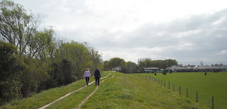
2009. Walkers on Stopbank, Pegasus Bay Walkway near Kaiapoi
On my way back Southern Alps were obscured by haze, caused by desert dust blown over the Tasman Sea from Australia. It reminded me of an Aussie beige haze over Christchurch in February, when bush fires burned Victoria. On my return to Kaiapoi, all I could see of the Alps was hazy Mount Thomas.

2009. Kaiapoi River upstream view, near BMX Track & Boatramp, Kaiapoi

2009. Kaiapoi River upstream view, Askeaton Park, Kaiapoi

2009. Whitebaiter, Kaiapoi River, near Charles Street, Kaiapoi
On the concrete path back at Kaiapoi, I watched a whitebaiter below willows haul his net from Kaiapoi River onto the riverbank. An elderly couple strolled past, back to their car, while I coolpixed the whirling bird statue below louring clouds. A fat man on his electric wheelchair nodded in greeting while he passed.

2009. Bird Statue on Stopbank, Pegasus Bay Walkway, Charles St, Kaiapoi. The stopbank & Charles St were damaged by the 4 Sept 2010 quake

2009. Walkers, Pegasus Bay Walkway, Kaiapoi River Stopbank, Kaiapoi. The Pegasus Bay Walkway & stopbank were damaged by the 4 Sept 2010 quake
Content & pics Copyright Mark JS Esslemont.

No comments:
Post a Comment